Hidden Hills
October 31, 2024
The day I visited Lassen National Park (formally known as Lassen Volcanic National Park) started off in Anderson, California. The drive to the park was beautiful; I especially enjoyed the small town of Chester. After Chester I entered a burned out area which my East Coast mind had a hard time digesting. I hear about forest fires in California and think how awful they are. But seeing them in person is a bit overwhelming in terms of the size of the area that is devastated. And it looks like it takes years to clean up and rebuild.
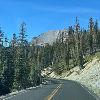
Closer to the park, I was out of the burned areas and just in the presence of towering fir trees. Quite a sensory experience.
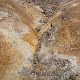
I used to manage four wood-burning power plants in the area of the park so I was prepared for the forests. But Lassen is volcanic — a small Yellowstone. I wasn’t prepared for the smell of sulphur, mudpots and fumerals. Spectacular views everywhere as I drive the narrow road through the park up to an elevation of over 8500 feet. On the other side of the 8500 feet the scenery is less active geothermal and more forests.
I met a fellow named Tim who is wandering around the US. He adds in weeks long trips to foreign countries (such as Vietnam, Cambodia, etc.). Interesting fellow.
About Lassen National Park:
Lassen Volcanic National Park is a national park in northeastern California. The dominant feature of the park is Lassen Peak, the largest plug dome volcano in the world and the southernmost volcano in the Cascade Range. Lassen Volcanic National Park is one of the few areas in the world where all four types of volcanoes can be found: plug dome, shield, cinder cone, and stratovolcano.
The source of heat for the volcanism in the Lassen area is subduction of the Gorda Plate diving below the North American Plate off the Northern California coast. The area surrounding Lassen Peak is still active with boiling mud pots, fumaroles, and hot springs.
Lassen Volcanic National Park started as two separate national monuments designated by President Theodore Roosevelt in 1907: Cinder Cone National Monument and Lassen Peak National Monument. Starting in May 1914 and lasting until 1917, a series of minor to major eruptions occurred on Lassen. Because of the eruptive activity and the area's stark volcanic beauty, Lassen Peak, Cinder Cone, and the area surrounding were established as a National Park on August 9, 1916.
The Lassen area was first protected by being designated as the Lassen Peak Forest Preserve. Lassen Peak and Cinder Cone were later declared as U.S. National Monuments in May 1907 by President Theodore Roosevelt.
Starting in May 1914 and lasting until 1921, a series of minor to major eruptions occurred on Lassen. These events created a new crater, and released lava and a great deal of ash. Fortunately, because of warnings, no one was killed, but several houses along area creeks were destroyed. Because of the eruptive activity, which continued through 1917, and the area's stark volcanic beauty, Lassen Peak, Cinder Cone and the area surrounding were declared a National Park on August 9, 1916.
The 29 mi (47 km) Main Park Road was constructed between 1925 and 1931, just 10 years after Lassen Peak erupted. Near Lassen Peak the road reaches 8,512 ft (2,594 m), making it the highest road in the Cascade Mountains. It is not unusual for 40 ft (12 m) of snow to accumulate on the road near Lake Helen and for patches of snow to last into July.
In October 1972, a portion of the park was designated as Lassen Volcanic Wilderness by the US Congress (Public Law 92-511). The National Park Service seeks to manage the wilderness in keeping with the Wilderness Act of 1964, with minimal developed facilities, signage, and trails. The management plan of 2003 adds that, "The wilderness experience offers a moderate to high degree of challenge and adventure."
In 1974, the National Park Service took the advice of the USGS and closed the visitor center and accommodations at Manzanita Lake. The Survey stated that these buildings would be in the way of a rockslide from Chaos Crags if an earthquake or eruption occurred in the area. An aging seismograph station remains. However, a campground, store, and museum dedicated to Benjamin F. Loomis stands near Manzanita Lake, welcoming visitors who enter the park from the northwest entrance.
After the Mount St. Helens eruption, the USGS intensified its monitoring of active and potentially active volcanoes in the Cascade Range. Monitoring of the Lassen area includes periodic measurements of ground deformation and volcanic-gas emissions and continuous transmission of data from a local network of nine seismometers to USGS offices in Menlo Park, California. Should indications of a significant increase in volcanic activity be detected, the USGS will immediately deploy scientists and specially designed portable monitoring instruments to evaluate the threat. In addition, the National Park Service (NPS) has developed an emergency response plan that would be activated to protect the public in the event of an impending eruption.
A downhill skiing site operating in the area was closed in 1992. The last remaining part was the Lassen Chalet, located near the southwest entrance, which was finally demolished in 2005. The new Kohm Yah-mah-nee Visitor Center opened to the public at the same location in 2008. It was so named after the Mountain Maidu name for Lassen Peak.
In 2021, the Dixie Fire burned large portions of the National Park, becoming the largest wildfire in park history.[14] On August 5, 2021, the fire entered Lassen Volcanic National Park near Juniper Lake and the entire park was closed for safety. The town of Mineral, including park headquarters, was forced to evacuate. Structure loss occurred at the Drakesbad Guest Ranch and at cabins near Juniper Lake. The Dixie Fire's advance northward was slowed by the 2012 Reading Fire footprint, but the Dixie Fire ultimately burned 73,240 acres within the park—approximately 69% of the park's total area. 12,845 acres, or 18% of that area, burned at a severity that left the landscape unchanged. 34,450 acres, or 49% of the burned area in the park, burned at a low-to-moderate severity. The remaining 23,493 acres, or 33% of the area burned by the Dixie Fire in Lassen Volcanic National Park, burned at a high severity.


Comments